
Torean Trekking Route – Mount Rinjani Complete Guide
Torean Trekking Route – Mount Rinjani’s Most Scenic Descent
The Torean Trekking Route is widely regarded as Mount Rinjani’s most scenic and dramatic trekking route, offering a completely different experience compared to the classic Sembalun and Senaru trails. This route is famous for its lush green valleys, Jurassic Park–like volcanic cliffs, waterfalls, river crossings, hot springs, and deep canyon landscapes, making it the most visually diverse route on the mountain.
Unlike the Sembalun route, which is dry and open with long uphill sections, or the Senaru route, which requires a steep and demanding ascent from Segara Anak Lake to the crater rim, the Torean route is predominantly downhill, especially from the lake onward. For this reason, Torean is best used as an exit route after completing the summit or lake trek, allowing trekkers to finish their journey in a more natural, scenic, and energy-efficient way.
Officially opened for trekking in 2020, the Torean route quickly gained popularity among experienced trekkers and nature-focused hikers who prioritize scenery, adventure, and trail variety. The route combines volcanic terrain with tropical forest, flowing rivers, and wide valleys—features rarely found together on other Rinjani routes.
Important Note
The minimum trekking program that uses the Torean route is 3 Days / 2 Nights (3D2N). Due to its distance, terrain complexity, and safety requirements, there is no 2D1N trekking option via Torean. The route is designed for multi-day treks that include either the summit, Segara Anak Lake, or both.
Torean Route Overview
The Torean Trekking Route begins in Torean Village (585 m), a quiet village on the northern side of Mount Rinjani, and leads trekkers through one of the mountain’s most dramatic and varied landscapes. From the very first day, the trail immerses you in lush rainforest terrain, flowing rivers, and cascading waterfalls before gradually opening into wide volcanic valleys.
Route Snapshot
- Starting Point: Torean Village (±585 m)
- Main Highlights: Penimbungan Waterfall, Jurassic Park–style cliffs, deep volcanic valleys, Segara Anak Lake, and natural hot springs
- Main Campsite: Propok Camp (around ±1,600 m), a strategic resting point before reaching the lake area
- Ending Points: Segara Anak Lake, Senaru Crater Rim, or Sembalun (depending on the chosen program)
- Difficulty Level: Moderate to Challenging
- Typical Duration: 3–4 days
Throughout the journey, trekkers experience a smooth transition from tropical forest to high-volcanic terrain, with scenery that constantly changes. The route is especially known for its long downhill sections after Segara Anak Lake, making it an excellent choice for trekkers who want a more comfortable and scenic final trekking day compared to the steep ascent required on the Senaru route.
Why Is the Torean Route So Popular?
The popularity of the Torean route comes from its unique combination of terrain, scenery, and trail character, which is very different from other routes on Mount Rinjani.
- Jurassic-Style Landscapes
Towering volcanic cliffs, narrow valleys, and dramatic rock formations create a wild and cinematic atmosphere rarely found on other routes. - Penimbungan Waterfall & River Corridors
The trail passes waterfalls, flowing rivers, and shaded forest paths, offering a cooler and more refreshing trekking environment. - Segara Anak Lake & Natural Hot Springs
Trekkers pass through Segara Anak Lake and nearby hot springs, providing a perfect recovery point after summit day. - Downhill-Focused Final Day
From the lake onward, the route follows a long descent through valleys and forest, making it especially suitable for trekkers who prefer to avoid long uphill climbs on the final day.
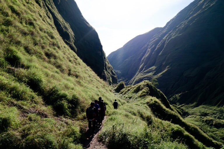
Trekking Trail Conditions – Narrow Valleys, Cliffs & River Corridors
The Torean Trekking Route passes through some of the most dramatic and naturally confined landscapes on Mount Rinjani. The trail follows narrow valleys, volcanic canyon walls, cliff-lined paths, and river corridors, which are key reasons why this route is considered the most scenic on the mountain.
These same features also mean that trekkers should clearly understand the trail conditions before choosing the Torean route, especially if they are unfamiliar with natural, non-constructed mountain trails.
Narrow Valley & Canyon Sections
Several sections of the Torean route pass through deep volcanic valleys, where the trail naturally follows the shape of the terrain. In these areas:
- The path may feel narrow, with rock walls or sloping terrain on one side
- Trekkers often walk along riverbeds or naturally carved trails between cliffs
- Space can feel more limited, particularly after rainfall when water levels increase
Under normal conditions, these sections are safe and manageable, but they require:
- Careful footing
- Awareness of surroundings
- Following guide instructions closely
This terrain gives the route its well-known “Jurassic Park” appearance and creates a trekking experience that feels wilder and more immersive than the Sembalun or Senaru routes.
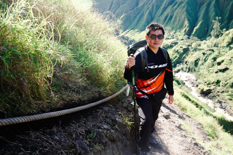
Cliff-Adjacent & Uneven Paths
In some parts of the route, the trail runs alongside steep volcanic slopes or rock formations. These paths are:
- Non-technical (no climbing skills required)
- Naturally formed, shaped by erosion and water flow
- Not equipped with fixed ropes or artificial structures
Trekkers may encounter:
- Loose volcanic stones
- Uneven steps
- Narrow footpaths where balance and focus are important
For these sections, good trekking shoes and trekking poles are strongly recommended, especially during downhill walking.
River Crossings & Seasonal Conditions
The Torean route includes multiple river crossings, which vary depending on season and rainfall:
- Dry season: crossings are generally shallow and straightforward
- Rainy season: water levels may rise, and the walking line may shift slightly
During periods of heavy rain:
- Guides may adjust pace, timing, or crossing points
- Extra care is required due to slippery rocks and stronger water flow
This is one of the main reasons why the Torean route is never offered as a short 2D1N trek, and is only used for multi-day programs with proper planning and support.
🌿 The Trekking Trail – Torean Route (By Sections)
🌋 Lower Section – Jungle and Waterfalls
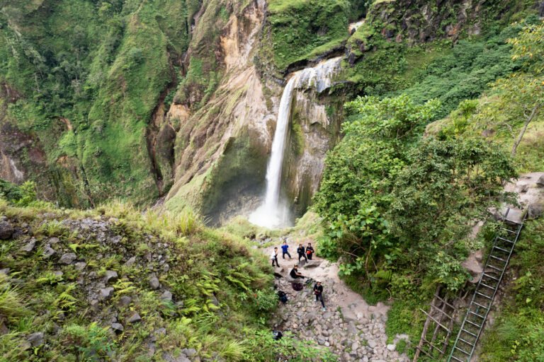
The trek begins in Torean Village, passing through farmland before entering dense tropical rainforest. This lower section follows riverbanks, shaded forest paths, and natural corridors, creating a cool and refreshing start to the trek. One of the early highlights is Penimbungan Waterfall, where water cascades into a deep green valley. This section is rich in vegetation, relatively sheltered from the sun, and offers a gentle introduction to the character of the Torean route.
🦖 Middle Section – Jurassic Cliffs & Volcanic Valleys
After the waterfall area, the trail gradually enters a more dramatic landscape of towering volcanic cliffs, narrow valleys, and rocky formations. This is the part of the route often compared to a “Jurassic Park” landscape. Here, the trail: Becomes more natural and uneven Follows the shape of the valley and surrounding cliffs Requires steady footing and awareness, especially on narrow sections While the terrain feels wilder and more remote, it remains non-technical and is safely managed when trekking with experienced local guides.
🏕️ Propok Campsite (±1,600 m)
Propok Camp is a wide and flat campsite surrounded by forest and volcanic walls. It serves as the main resting point before reaching Segara Anak Lake. From this point onward, trekkers begin to notice a gradual change in landscape—from dense jungle to more open volcanic terrain, signaling the transition toward the caldera area.
♨️ Upper Section – Rivers, Volcanic Terrain & Lake Approach
Between Propok Camp and Segara Anak Lake, the trail becomes more physically demanding, with longer walking sections across rocky paths, volcanic soil, and occasional riverbeds. Depending on weather conditions: Some sections may feel slippery after rain Trekking poles and good-grip shoes are strongly recommended Despite this, the route maintains a steady and logical progression, without technical climbing.
🌊 Segara Anak Lake & Natural Hot Springs
The journey culminates at Segara Anak Lake, located inside Mount Rinjani’s vast caldera at around 2,000 meters above sea level. This area is a key highlight of the Torean route. Nearby natural hot springs allow trekkers to soak, relax, and recover after long trekking days, making it an ideal resting point before continuing toward the summit or the final descent.
All Trekking Programs Can Connect with the Torean Trekking Route
- 3day 2night
- Challenging
start price
$ 280.00
Sembalun Torean 3D2N – Mount Rinjani Summit Trek (3,726 m)
- semablun- summit -lake hot spring torean route
Final Thoughts
The Torean Trekking Route offers one of the most dramatic and rewarding experiences on Mount Rinjani. With waterfalls, rivers, volcanic terrain, hot springs, and fewer crowds, it is ideal for trekkers who value scenery, adventure, and immersion in nature. When combined with Senaru or Sembalun, the Torean route completes a truly unforgettable Mount Rinjani journey.