
Mount Rinjani Routes, Terrain Characteristics, and Fitness Requirements
Mount Rinjani offers a wide variety of trekking routes, each with different terrain, elevation profiles, scenery, and difficulty levels. Understanding these routes clearly is essential for choosing the right trek, preparing properly, and trekking safely inside Mount Rinjani National Park.
This guide explains all officially recognized trekking routes on Mount Rinjani, including summit routes, crater rim routes, and eco-trekking routes, so travelers can make informed and responsible decisions.
Official Trekking Routes on Mount Rinjani
Mount Rinjani National Park officially recognizes six legal trekking routes. Trekking outside these routes is illegal and unsafe.
The routes are divided into:
- Summit & crater routes
- Eco-trekking and conservation routes
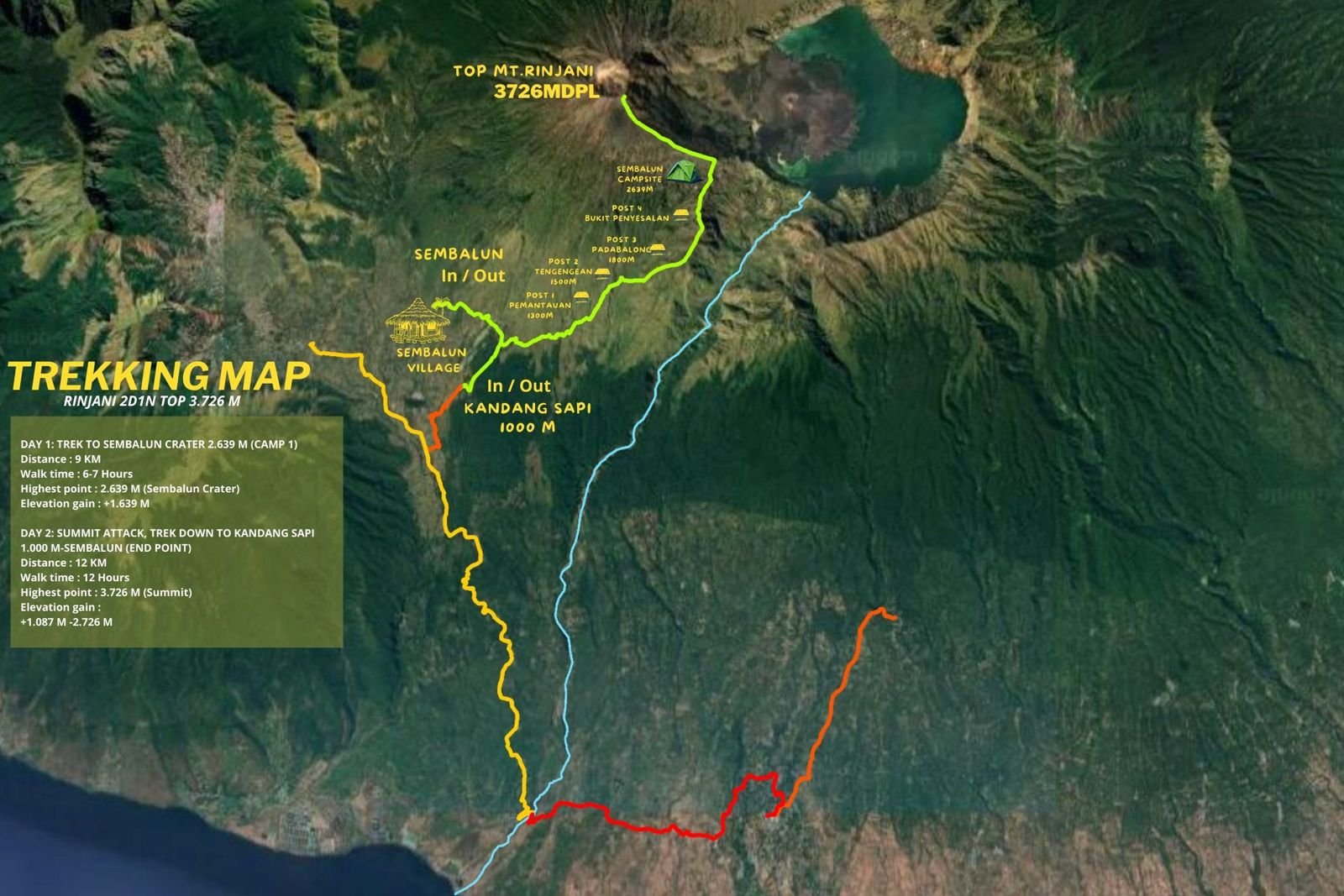
Sembalun Route – Summit Route (East Rinjani)
Profile
- Start point: Sembalun Village (1,156 m)
- Highest point: Mount Rinjani Summit (3,726 m)
- Typical duration: 3–5 days
- Elevation gain: High
Terrain & Trail Character
The Sembalun Route crosses wide open grasslands and rolling hills before reaching the Sembalun Crater Rim (2,639 m). The trail is largely exposed, with limited shade. The summit push begins around early morning hours and involves very steep climbing on loose volcanic sand, where footing can be unstable.
Difficulty Level
- Physical: High
- Technical: Moderate
- Mental: High
Suitable For
- Trekkers aiming for the summit
- Physically prepared hikers
- Those comfortable with long uphill walking, cold, and wind
Main Challenges
- Hot daytime conditions
- Strong wind at night
- Extremely steep summit section

Senaru Route – Forest & Crater Rim Route (North Rinjani)
Profile
- Start point: Senaru Village (601 m)
- Main destination: Senaru Crater Rim (2,641 m)
- Typical duration: 2 days / 1 night
- Elevation gain: Moderate to high
Terrain & Trail Character
This route passes through dense tropical rainforest with shaded trails, stone steps, and high humidity. The climb is steady and continuous until reaching the crater rim, offering panoramic views of Segara Anak Lake and Mount Barujari.
Difficulty Level
- Physical: Moderate
- Technical: Low
- Mental: Moderate
Suitable For
- First-time trekkers with good fitness
- Those seeking scenic views without summiting
- Forest and nature lovers
Main Challenges
- Long continuous ascent
- Slippery steps during rainy conditions

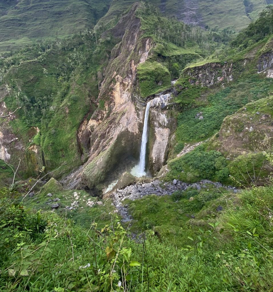
Torean Route – Valley, River & Waterfall Route (Northwest Rinjani)
Profile
- Exit point: Torean Village
- Typical use: Descent route after summit
- Elevation change: Long descent
Terrain & Trail Character
The Torean Route follows river valleys, narrow trails, rocky terrain, waterfalls, and hot springs near Segara Anak Lake. It offers dramatic scenery but involves more technical terrain and demands good balance and physical endurance.
Difficulty Level
- Physical: High
- Technical: Moderate to high
- Mental: Moderate
Suitable For
- Experienced trekkers
- Descent after summit via Sembalun
- Those confident on uneven and slippery terrain
Main Challenges
- Narrow paths and rocky sections
- Slippery surfaces and river crossings
Tetebatu Route – Eco Trekking Route (South Rinjani)
Profile
- Start point: Tetebatu Village
- Elevation: Low to mid-altitude
- Typical duration: 1–2 days
Terrain & Trail Character
This route passes rice terraces, bamboo forests, waterfalls, and traditional villages. It does not lead to the summit or crater rim and focuses on eco-tourism, nature walks, and cultural experiences.
Difficulty Level
- Physical: Easy to moderate
- Technical: Low
- Mental: Low
Suitable For
- Beginners
- Families
- Travelers focused on culture and soft trekking
Timbanuh Route – South Rinjani Forest & Conservation Route
Profile
- Start point: Timbanuh Village, East Lombok
- Elevation: Low to mid-altitude
- Typical duration: 1 day or soft overnight trek
Terrain & Trail Character
The Timbanuh Route runs through dense forest, farmland, and quiet mountain trails. It was developed specifically for eco-trekking, conservation, and educational purposes rather than high-altitude trekking.
Difficulty Level
- Physical: Easy to moderate
- Technical: Low
- Mental: Low
Suitable For
- Beginners and casual hikers
- Educational groups
- Travelers interested in forest ecology
Important Notes
- No access to crater rim or summit
- Less crowded and very peaceful
Aik Berik Route – Rainforest & Waterfall Route
Profile
- Start point: Aik Berik Village, Central Lombok
- Elevation: Low to mid-altitude
- Typical duration: Half-day to full-day trek
Terrain & Trail Character
The Aik Berik Route follows rivers and rainforest paths and is well known for its waterfalls. It highlights Rinjani’s role as Lombok’s main water source and focuses on forest conservation.
Difficulty Level
- Physical: Easy
- Technical: Low
- Mental: Low
Suitable For
- Families and beginner trekkers
- Short nature walks
- Visitors during summit closure season
Important Notes
- No summit or crater access
- Ideal year-round, weather permitting
Difficulty Comparison Summary
Easy:
- Aik Berik Route
- Tetebatu Route
Moderate:
- Senaru Crater Rim Route
- Timbanuh Route
Challenging:
- Sembalun Summit Route
- Torean Route
Difficulty increases significantly with altitude, duration, cold temperature, and terrain exposure.
Physical & Mental Preparation Requirements
Trekkers should be prepared for:
- 6–10 hours of walking per day (summit programs)
- Cold night temperatures (0–10°C)
- Strong wind and sudden weather changes
- Limited facilities and no permanent shelters
Good preparation includes regular cardio exercise, leg strength training, and mental readiness for fatigue and unpredictable conditions.
Important Clarification on Route Usage
Only Sembalun Route provides legal access to the summit.
Only Senaru and Sembalun routes reach crater rim viewpoints.
Timbanuh, Aik Berik, and Tetebatu routes are eco-trekking routes only and cannot be used to reach the summit or Segara Anak Lake.
Choosing the wrong route leads to false expectations and safety risks.
Final Notes
Each Mount Rinjani route serves a different purpose. Summit routes challenge physical limits, crater rim routes offer dramatic views, and eco-trekking routes provide cultural and environmental experiences.
Responsible trekking means choosing a route that matches your ability, respecting National Park regulations, and listening to guide decisions at all times.
Proper route selection is the foundation of a safe, meaningful, and unforgettable Mount Rinjani trekking experience.
