
Mount Rinjani routes and difficulty should be clearly understood before choosing any trekking program. Each route on Mount Rinjani has different terrain, elevation, scenery, weather exposure, and physical challenges.
Some routes are designed for summit trekking, some are better for crater rim views, while others are suitable for lake, hot springs, waterfalls, forest walks, or soft eco-trekking. Choosing the right route helps trekkers prepare properly, avoid false expectations, and enjoy a safer trekking experience inside Mount Rinjani National Park.
This guide explains the main Mount Rinjani routes and difficulty levels, including Sembalun, Senaru, Torean, Tetebatu, Timbanuh, and Aik Berik, so you can choose the most suitable route based on your fitness level, trekking goal, and available travel time.
Mount Rinjani Routes and Difficulty – Quick Route Comparison
The following Mount Rinjani routes and difficulty comparison gives a simple overview of each route, its main purpose, and the type of trekker it is suitable for.
| Route | Best For | Difficulty | Main Character |
|---|---|---|---|
| Sembalun Route | Summit trekking | Challenging | Open savanna, summit trail, volcanic sand |
| Senaru Route | Crater rim and forest trek | Moderate to challenging | Rainforest, steady climb, crater rim views |
| Torean Route | Lake, hot springs, and scenic descent | Challenging | Valley, river, waterfalls, rocky sections |
| Tetebatu Route | Eco-trekking and soft adventure | Easy to moderate | Rice fields, forest, villages |
| Timbanuh Route | Conservation and forest trekking | Easy to moderate | Quiet forest and educational route |
| Aik Berik Route | Waterfalls and short nature walk | Easy | Rainforest, river, waterfall scenery |
Each route offers a different experience. The Sembalun Route is best for summit programs, the Senaru Route is popular for crater rim trekking, and the Torean Route is known for lake access, hot springs, valleys, and dramatic scenery. Tetebatu, Timbanuh, and Aik Berik are better suited for soft trekking, waterfalls, eco-tourism, and nature-based experiences.
Official Mount Rinjani Trekking Routes
Sembalun Route – Best Route for Summit Trekking
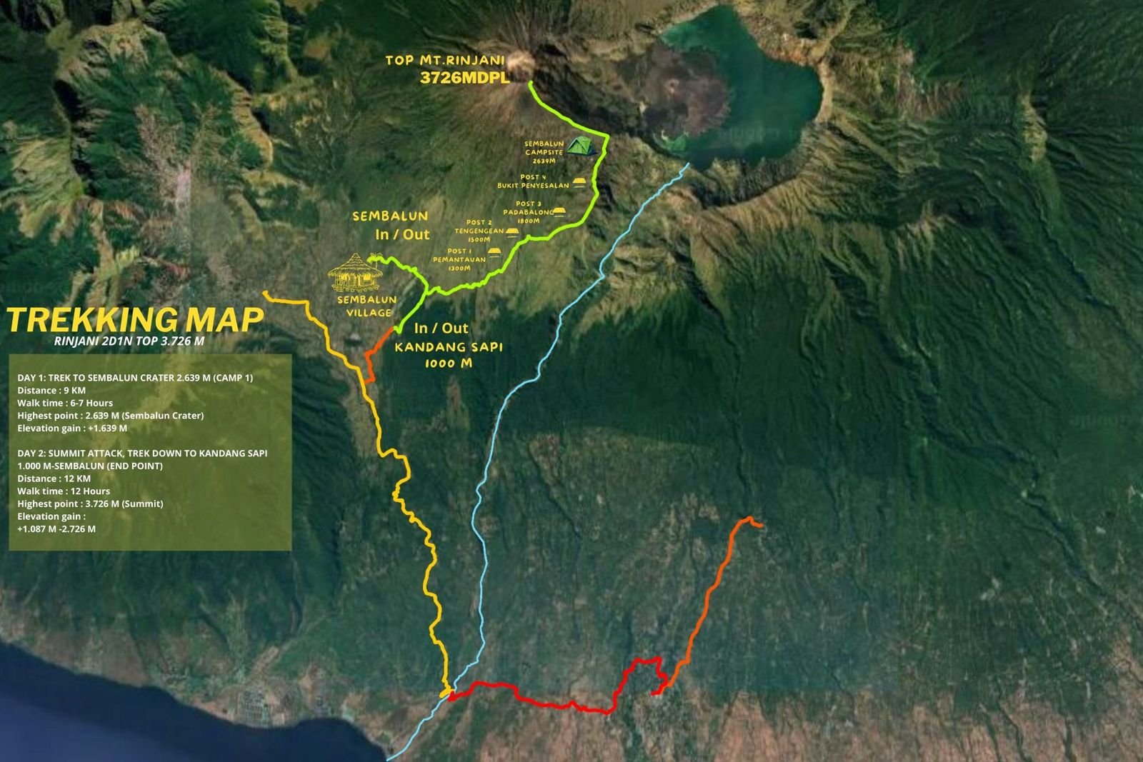
The Sembalun Route is the most popular route for trekkers who want to reach the summit of Mount Rinjani. This route starts from Sembalun Village on the eastern side of Lombok and gradually climbs through open grassland, rolling hills, and exposed savanna before reaching Sembalun Crater Rim.
The main reason trekkers choose the Sembalun Route is because it provides the most common access to the summit of Mount Rinjani. The route is also included in many summit programs such as 2D1N Summit Sembalun, 3D2N Sembalun to Senaru, 3D2N Sembalun to Torean, 4D3N Sembalun to Torean, and longer expedition-style treks.
Route Profile
- Start point: Sembalun Village
- Main destination: Mount Rinjani summit, Sembalun Crater Rim, and Segara Anak Lake on longer programs
- Terrain: open savanna, rolling hills, volcanic sand, exposed summit trail
- Difficulty: challenging
- Best for: summit seekers and physically prepared trekkers
Terrain and Trail Conditions
The first part of the Sembalun Route passes through open savanna with wide views of the surrounding hills. During sunny weather, this section can feel hot because there is limited shade. After passing the lower posts, the trail becomes steeper as trekkers climb toward Sembalun Crater Rim.
The most difficult part of this route is the summit push. This section usually starts around midnight or early morning, depending on the program and weather conditions. The summit trail is steep, cold, windy, and covered with loose volcanic sand. Trekkers often move slowly because the ground can slide backward with each step.
Difficulty Level
The Sembalun Route is considered challenging because of the long trekking hours, strong sun exposure during the day, cold conditions at night, and the physically demanding summit section.
This route requires good stamina, strong legs, mental preparation, and the ability to walk for several hours on uneven terrain.
Best For
The Sembalun Route is best for:
- Trekkers who want to reach the summit
- Guests with good fitness
- Hikers who are comfortable with long uphill walking
- Travelers looking for a classic Mount Rinjani summit experience
- Trekkers who want to combine summit, crater rim, lake, and hot springs on longer programs
Not Ideal For
This route may not be ideal for:
- Guests with very low fitness
- Beginners who are not physically prepared
- Travelers who only want an easy nature walk
- Guests who are uncomfortable with cold, wind, or early morning climbing
Main Challenges
The main challenges on the Sembalun Route are hot daytime conditions, limited shade, steep elevation gain, cold crater rim nights, and the demanding summit push through volcanic sand.
Senaru Route – Best for Crater Rim and Forest Trekking
The Senaru Route starts from Senaru Village on the northern side of Mount Rinjani. This route is best known for its dense tropical rainforest, shaded trail, steady uphill climb, and beautiful views from Senaru Crater Rim.
For many travelers, the Senaru Route is the best choice if they want to experience Mount Rinjani without climbing to the summit. The 2D1N Senaru Crater Rim trek is one of the most popular non-summit programs because it offers impressive views of Segara Anak Lake and Mount Barujari from the crater rim.
Route Profile
- Start point: Senaru Village
- Main destination: Senaru Crater Rim
- Terrain: tropical rainforest, roots, stone steps, shaded trail, steady climb
- Difficulty: moderate to challenging
- Best for: crater rim views, forest trekking, and non-summit trekking
Terrain and Trail Conditions
The Senaru Route begins in tropical rainforest. The trail is mostly shaded, which makes it cooler than the open Sembalun savanna. However, the climb is steady and continuous, and the humidity can make the trek feel physically demanding.
Trekkers should expect forest roots, stone steps, uneven ground, and long uphill sections. After several hours of climbing, the forest slowly opens toward Senaru Crater Rim, where trekkers can enjoy wide views of Segara Anak Lake and the surrounding crater landscape.
Difficulty Level
The Senaru Route is moderate to challenging. It does not include the summit, but the long continuous climb requires good fitness. The descent can also be tiring for the knees, especially after rain when some sections may become slippery.
Best For
The Senaru Route is best for:
- Guests who want crater rim views without the summit
- Beginner to intermediate trekkers with good fitness
- Travelers who enjoy forest trails
- Guests with limited time who want a 2D1N Rinjani experience
- Trekkers who prefer a less exposed route than Sembalun
Not Ideal For
This route is not ideal for guests who expect to reach the summit, visit the lake, or enjoy hot springs within a short 2D1N program. The standard 2D1N Senaru Crater Rim trek reaches the crater rim only and does not descend to Segara Anak Lake.
Main Challenges
The main challenges are the long continuous uphill climb, humidity inside the forest, slippery trail sections during wet conditions, and a long descent back to Senaru.
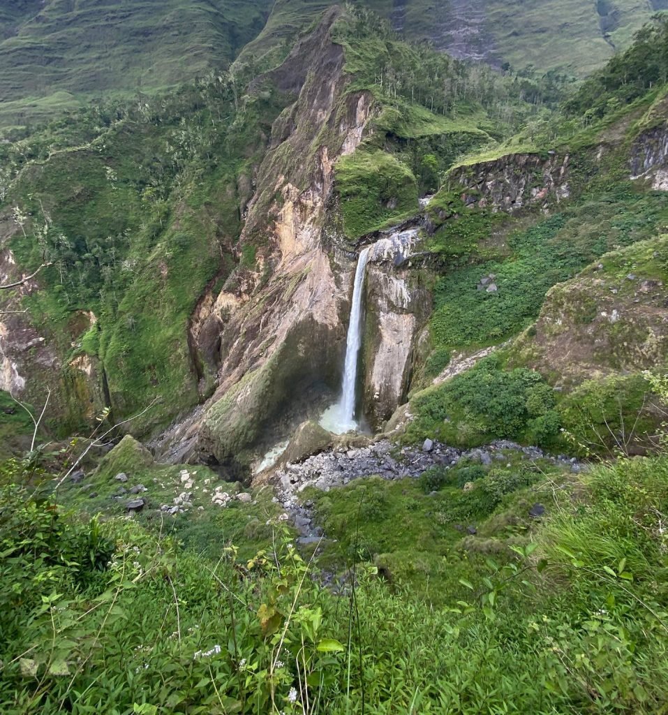
Torean Route – Scenic Valley Route with Higher Technical Terrain
The Torean Route is one of the most scenic routes on Mount Rinjani. It is known for dramatic valley views, river sections, waterfalls, rocky trails, and access toward Segara Anak Lake and the hot springs area. The official TNGR website highlights Penimbungan Waterfall as a scenic feature located on the Torean trekking route.
In many trekking programs, the Torean Route is used as a descent route after starting from Sembalun, reaching the summit, and visiting Segara Anak Lake. This creates a complete trekking experience with summit views, lake camping, hot springs, and a dramatic valley descent.
Route Profile
- Start or exit point: Torean Village
- Common use: scenic descent route after summit or lake programs
- Terrain: valley trail, rocky paths, river sections, narrow tracks, waterfall views
- Difficulty: challenging
- Best for: experienced trekkers and scenic adventure routes
Terrain and Trail Conditions
The Torean Route is very different from Sembalun and Senaru. Instead of open savanna or dense rainforest, this route follows a more dramatic valley landscape. Trekkers may pass rocky sections, narrow paths, river areas, and scenic viewpoints.
Although the route is beautiful, it requires careful footing and good balance. Some sections can feel more technical than the classic Senaru descent, especially when the trail is wet or slippery.
Difficulty Level
The Torean Route is challenging. It is not only physically demanding but also requires attention and confidence on uneven terrain. Trekkers should be prepared for a long descent, rocky sections, and changing trail conditions.
Best For
The Torean Route is best for:
- Trekkers who want a scenic descent
- Guests choosing Sembalun to Torean programs
- Experienced hikers
- Travelers who want lake, hot springs, valley, and waterfall scenery
- Trekkers who are comfortable with uneven and rocky trails
Not Ideal For
This route may not be ideal for guests who want an easy downhill walk, travelers with poor balance, or those with serious knee problems.
Main Challenges
The main challenges on the Torean Route are narrow paths, rocky sections, slippery terrain, river areas, long walking distance, and the physical demand of descending through a remote valley.
Tetebatu Route – Eco Trekking and Soft Adventure
The Tetebatu Route is different from the main summit and crater rim routes. It is better known for soft trekking, local village scenery, rice fields, forest walks, waterfalls, and cultural experiences around the southern side of Mount Rinjani.
This route does not provide access to the main summit or the classic crater rim trekking programs. Instead, it is more suitable for travelers who want a lighter nature experience without high-altitude trekking or overnight mountain camping.
Route Profile
- Start point: Tetebatu area
- Main experience: eco-trekking, rice fields, waterfalls, local village scenery
- Terrain: farmland, village paths, forest sections, soft nature trails
- Difficulty: easy to moderate
- Best for: beginners, families, culture, and soft adventure
Terrain and Trail Conditions
The Tetebatu Route usually passes through greener and lower-altitude landscapes. Depending on the chosen program, guests may walk through rice terraces, bamboo forests, village paths, and waterfall areas.
The trail is generally easier than Sembalun, Senaru, or Torean, but conditions may still vary depending on rain and the exact walking route.
Difficulty Level
Tetebatu is easy to moderate. It is suitable for travelers who want to enjoy the natural atmosphere of the Rinjani area without committing to a challenging summit or crater rim trek.
Best For
Tetebatu is best for:
- Beginners
- Families
- Travelers interested in local culture
- Guests who want soft trekking
- Visitors looking for waterfalls, rice fields, and village scenery
Important Note
Tetebatu should not be confused with the main summit route. It is not suitable for guests who want to reach the summit, crater rim, Segara Anak Lake, or hot springs.
Timbanuh Route – Forest and Conservation Route
The Timbanuh Route is another eco-trekking and conservation-based route on the southern side of Mount Rinjani. It is generally quieter than the main trekking routes and is more focused on forest experience, conservation, education, and soft adventure.
This route is not one of Green Rinjani’s main commercial summit routes, but it is important to explain it clearly because some travelers may see the name online and assume it gives access to the summit or lake.
Route Profile
- Start point: Timbanuh area
- Main experience: forest trekking, conservation, quiet nature route
- Terrain: forest trail, farmland, lower to mid-altitude paths
- Difficulty: easy to moderate
- Best for: eco-trekking, education, conservation, and peaceful forest walks
Terrain and Trail Conditions
The Timbanuh Route generally passes through forested areas and quieter mountain landscapes. It does not have the same high-altitude exposure as Sembalun or Senaru, and it is not normally used for classic summit programs.
Difficulty Level
The route is easy to moderate, depending on the distance and program style. It may still require basic fitness, especially if the trail is wet, muddy, or longer than expected.
Best For
Timbanuh is best for:
- Forest lovers
- Casual hikers
- Educational groups
- Travelers interested in conservation
- Guests looking for a quieter route
Important Note
Timbanuh is not a standard route for reaching the Mount Rinjani summit, Segara Anak Lake, or the main crater rim viewpoints used in classic Rinjani trekking programs.
Aik Berik Route – Waterfall and Rainforest Route
The Aik Berik Route is best known for rainforest, river scenery, and waterfall experiences in Central Lombok. It is a soft trekking option and is more suitable for short nature walks than high-altitude mountain trekking.
This route is often a good option for travelers who want to enjoy the natural beauty around Mount Rinjani without joining a difficult summit or crater rim trek.
Route Profile
- Start point: Aik Berik, Central Lombok
- Main experience: rainforest, rivers, waterfalls, short nature walk
- Terrain: forest paths, river areas, waterfall access trails
- Difficulty: easy
- Best for: beginners, families, short nature walks, and waterfall visitors
Terrain and Trail Conditions
The Aik Berik Route usually follows rainforest and river areas. The terrain is generally easier than the main Rinjani trekking routes, but it can still become slippery during or after rain.
Difficulty Level
Aik Berik is considered easy compared to the summit, crater rim, and Torean routes. It is more suitable for visitors who want a light adventure rather than a full mountain expedition.
Best For
Aik Berik is best for:
- Families
- Beginner trekkers
- Short nature walks
- Waterfall lovers
- Travelers visiting Central Lombok
Important Note
Aik Berik does not provide access to the Mount Rinjani summit, Segara Anak Lake, or the main crater rim viewpoints used in classic Rinjani trekking programs.
Difficulty Level Explained
Understanding the difficulty level of each route helps guests choose a program that matches their fitness, experience, and expectations.
Mount Rinjani difficulty is not only about distance. It is also affected by altitude, trail surface, weather, temperature, backpack weight, trekking duration, and mental readiness.
Easy
Easy routes are suitable for guests who want a light nature experience without high-altitude trekking or overnight camping. These routes may still require walking on uneven ground, but they are not as demanding as summit or crater rim routes.
Easy routes are suitable for:
- Beginners
- Families
- Short nature walks
- Waterfall visitors
- Travelers who do not want camping or high-altitude trekking
Examples:
- Aik Berik Route
- Some Tetebatu soft trekking programs
Moderate
Moderate routes require better fitness and more preparation. Guests should be comfortable walking uphill for several hours and descending on uneven trails.
Moderate routes are suitable for:
- Active travelers
- Beginner to intermediate trekkers
- Guests with basic hiking experience
- Travelers who are prepared for steady uphill walking
Examples:
- Senaru Crater Rim Route
- Tetebatu or Timbanuh soft trekking, depending on the route and duration
Challenging
Challenging routes require strong fitness, endurance, proper gear, and mental preparation. These routes may include long trekking days, cold nights, steep climbs, rocky paths, volcanic sand, and technical descents.
Challenging routes are suitable for:
- Fit trekkers
- Experienced hikers
- Summit seekers
- Guests comfortable with long trekking hours
- Travelers prepared for cold, wind, and difficult terrain
Examples:
- Sembalun Summit Route
- Torean Route
- 3D2N and 4D3N summit programs
Difficulty by Trekking Goal
Understanding Mount Rinjani routes and difficulty is not only about distance, but also about terrain, altitude, weather, and physical endurance.
Different trekking goals require different routes. Choosing the right route is important because not every route leads to the summit, crater rim, lake, or hot springs.
| Trekking Goal | Recommended Route | Difficulty |
|---|---|---|
| Reach the summit | Sembalun Route | Challenging |
| See Segara Anak Lake from above | Senaru Crater Rim | Moderate to challenging |
| Visit Segara Anak Lake and hot springs | Sembalun–Senaru, Sembalun–Torean, or Senaru–Torean | Challenging |
| Short forest trekking | Senaru or Aik Berik | Easy to moderate |
| Waterfall and soft trekking | Tetebatu or Aik Berik | Easy |
| Scenic valley descent | Torean Route | Challenging |
| Complete Rinjani experience | 4D3N or 5D4N summit and lake program | Challenging |
Fitness Requirements for Mount Rinjani Trekking
Mount Rinjani requires good physical preparation, especially for summit and multi-day trekking programs. Even non-summit routes can be tiring because of continuous uphill and downhill walking.
For most trekking programs, guests should be prepared for several hours of walking per day. Summit programs can involve longer trekking hours, especially on the day of the summit push.
General Fitness Requirements
Trekkers should be prepared for:
- 5–8 hours of walking per day on regular trekking days
- Longer walking hours on summit day, depending on the program
- Steep uphill and downhill sections
- Cold nights at higher campsites
- Uneven trail surfaces
- Limited facilities on the mountain
- Physical fatigue over multiple days
Recommended Preparation
Before trekking Mount Rinjani, it is recommended to prepare with:
- Regular walking or hiking
- Stair climbing
- Cardio training
- Leg strength exercises
- Balance training
- Light backpack walking practice
You do not need to be a professional athlete, but you should have enough stamina and mental readiness for long hours on the trail.
Common Mistakes When Choosing a Rinjani Route
Many problems happen because guests choose a route based only on photos, price, or limited time without understanding the real difficulty.
Common mistakes include:
- Choosing a 2D1N summit program without enough fitness
- Thinking the Senaru Crater Rim trek includes the summit
- Thinking Torean is an easy shortcut
- Choosing a route only because it looks beautiful in photos
- Booking a flight or boat too soon after trekking
- Not checking permit and route availability
- Ignoring weather and trail conditions
- Underestimating the cold temperature at crater rim or summit
- Choosing the cheapest option without checking what is included
- Not preparing proper shoes and clothing
Choosing the wrong route can lead to fatigue, disappointment, safety risks, or unrealistic expectations.
Which Mount Rinjani Route Should You Choose?
The best route depends on your goal, fitness level, available time, and comfort with mountain conditions.
Choose the Sembalun Route if:
- You want to reach the summit
- You are physically prepared
- You want the classic Rinjani summit experience
- You are comfortable with open savanna and steep volcanic sand
Choose the Senaru Route if:
- You want crater rim views without the summit
- You prefer forest trekking
- You have limited time
- You want a 2D1N non-summit Rinjani experience
Choose the Torean Route if:
- You want dramatic valley scenery
- You want a scenic descent after summit or lake trekking
- You are comfortable with rocky and uneven terrain
- You choose a Sembalun to Torean or lake and hot springs program
Choose Tetebatu or Aik Berik if:
- You want soft trekking
- You are traveling with family
- You prefer waterfalls, forest, and village scenery
- You do not want high-altitude trekking or camping
Choose a Longer Program if:
- You want a more complete Rinjani experience
- You want summit, lake, hot springs, and scenic descent
- You prefer a better pace with more recovery time
- You want to reduce the pressure of a fast itinerary
For most guests who want the best complete experience, a 4D3N or 5D4N program is more comfortable than a fast 2D1N or 3D2N summit itinerary.
Important Safety Note
Route availability, official permits, and trekking regulations may change depending on national park policy, weather conditions, conservation programs, seasonal closure, and trail safety assessments. Guests should always confirm the current route status before booking.
The official Mount Rinjani National Park website has published updates mentioning the trekking routes Senaru, Sembalun, Torean, Timbanuh, Tetebatu, and Aik Berik in relation to temporary closures and route management, so guests should always follow the latest official updates before trekking.
Green Rinjani will always prioritize guest safety, official permit rules, and current trail conditions when recommending or confirming a trekking route.
Important Clarification on Route Usage
Not every route leads to the same destination. This is very important for guests to understand before booking.
The Sembalun Route is the main route used for summit trekking. The Senaru Route is widely used for crater rim trekking and forest-based programs. Torean is commonly used for scenic descent, lake, and valley programs.
Tetebatu, Timbanuh, and Aik Berik are better understood as eco-trekking, waterfall, forest, and soft adventure routes. These routes should not be confused with the main summit, lake, or crater rim trekking programs.
Choosing the wrong route can create false expectations. Guests should always confirm whether their selected program includes the summit, crater rim, Segara Anak Lake, hot springs, or only soft trekking.
Final Notes
Use this Mount Rinjani routes and difficulty guide as a practical reference before choosing your trekking route, especially if you are unsure between summit, crater rim, lake, or soft trekking options.
Each Mount Rinjani route serves a different purpose. Summit routes challenge physical endurance, crater rim routes offer dramatic lake views, Torean provides scenic valley adventure, and eco-trekking routes give travelers a softer nature and cultural experience.
Responsible trekking means choosing a route that matches your ability, respecting national park regulations, preparing properly, and following guide instructions at all times.
Proper route selection is the foundation of a safe, meaningful, and unforgettable Mount Rinjani trekking experience.
