
The official Mount Rinjani trekking routes provide several ways to explore the summit, crater rims, Segara Anak Lake, natural hot springs, tropical forest, volcanic valleys, waterfalls, and the surrounding landscapes of Mount Rinjani National Park.
Each route offers a different trekking experience. Sembalun is the primary choice for trekkers aiming to reach the 3,726-metre summit. Senaru is known for its tropical forest, crater-rim views, and access toward Segara Anak Lake. Torean offers a dramatic route through valleys, cliffs, rivers, waterfalls, and natural hot springs.
Mount Rinjani National Park also recognizes Timbanuh, Tetebatu, and Aik Berik as official trekking routes. These alternative trails provide different landscapes and are generally less frequently used than the main Sembalun, Senaru, and Torean routes.
There is no single route that is suitable for every visitor. The right choice depends on your trekking goal, available time, physical condition, previous hiking experience, preferred scenery, and whether reaching the summit is your main priority.
This guide compares the official Mount Rinjani trekking routes, explains the main characteristics of each trail, and helps you select the most suitable trekking program.
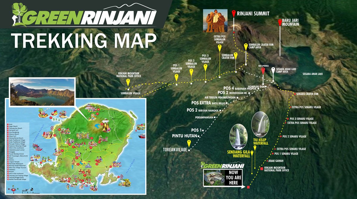
Mount Rinjani Trekking Routes at a Glance
| Route | Best for | Main landscape | General difficulty |
|---|---|---|---|
| Sembalun | Summit trekking | Open savanna, crater rim, volcanic summit trail | Challenging to very challenging |
| Senaru | Crater rim and forest trekking | Tropical forest, crater views, lake access | Moderate to challenging |
| Torean | Lake routes and scenic descent | Valleys, cliffs, rivers, waterfalls | Challenging and technical |
| Timbanuh | Alternative crater-rim trekking | Forest, hills, and quieter landscapes | Moderate to challenging |
| Tetebatu | Nature-focused trekking | Forest, rural landscapes, and mountain views | Moderate |
| Aik Berik | Southern Rinjani exploration | Forest, waterfalls, hills, and natural scenery | Moderate to challenging |
Sembalun, Senaru, and Torean are the routes most commonly used for Green Rinjani multi-day trekking programs. Timbanuh, Tetebatu, and Aik Berik are alternative official trails whose availability, itinerary, and access arrangements should be confirmed before booking.
How Many Official Mount Rinjani Trekking Routes Are There?
Mount Rinjani National Park currently recognizes six official trekking routes:
- Sembalun
- Senaru
- Torean
- Timbanuh
- Tetebatu
- Aik Berik
These routes do not all provide the same access to the summit, crater lake, crater rim, or hot springs.
The most suitable route depends on what the trekker wants to experience:
- Choose Sembalun when reaching the summit is the main goal.
- Choose Senaru for tropical forest and crater-rim trekking.
- Choose Torean for lake access and a scenic valley descent.
- Consider Timbanuh, Tetebatu, or Aik Berik for an alternative and generally quieter Rinjani experience.
Route availability can change because of seasonal closure, maintenance, weather, natural hazards, national park regulations, or safety assessments. Guests should confirm the latest status before making travel arrangements.
Sembalun Trekking Route
The Sembalun route is the main starting trail for Mount Rinjani summit programs. It begins on the eastern side of the mountain and is widely used for 2D1N, 3D2N, 4D3N, and longer summit itineraries.
The first section crosses open grassland and savanna. Compared with the forested Senaru trail, Sembalun provides less natural shade and can feel hot during the daytime. The route gradually climbs through several rest posts before reaching the steeper ascent toward Sembalun Crater Rim.
The crater-rim campsite offers views toward:
- Mount Rinjani summit
- Segara Anak Lake
- Mount Barujari
- The surrounding crater walls
- Sembalun Valley
- Sunrise and sunset landscapes
The summit attempt normally begins during the night or early morning. Trekkers climb from the crater rim toward the 3,726-metre summit over loose volcanic sand, gravel, and exposed terrain.
Best For
The Sembalun route is best suited to:
- Trekkers whose main goal is the summit
- Physically prepared hikers
- Guests comfortable with long uphill walking
- Trekkers joining multi-day summit and lake programs
- Visitors who enjoy open savanna landscapes
Main Challenges
The main challenges include:
- Long exposure to sun on the first day
- Limited shade across the savanna
- A demanding climb toward the crater rim
- Cold temperatures and strong wind at higher elevation
- Loose volcanic terrain during the summit attempt
- Significant elevation gain over a relatively short period
The summit section is the most physically demanding part of the standard Mount Rinjani trekking experience. Reaching the crater rim does not automatically mean every participant will be able to continue to the summit.
The guide will assess weather, timing, group condition, and individual safety before and during the summit attempt.
Common Sembalun Programs
Common programs using the Sembalun route include:
- 2D1N Sembalun Summit to Sembalun
- 3D2N Sembalun Summit to Senaru
- 3D2N Sembalun Summit to Torean
- 4D3N Sembalun Summit to Senaru
- 4D3N Sembalun Summit to Torean
- 5D4N Mount Rinjani expedition
A Sembalun start can finish through Sembalun, Senaru, or Torean depending on the registered program.
Senaru Trekking Route
The Senaru route begins on the northern side of Mount Rinjani. It is known for dense tropical forest, shaded trails, large trees, wildlife sounds, and a gradual transition from humid lowland forest to higher mountain terrain.
Senaru is commonly used for crater-rim programs that do not include the summit. It can also be used as an entry or exit route for longer itineraries involving Segara Anak Lake, the hot springs, and the opposite side of the mountain.
The forest provides more shade than the Sembalun savanna, but the route still involves a long and steady climb. Tree roots, rocks, soil, mud, and steep sections can make the trail demanding, especially during or after rainfall.
The Senaru Crater Rim provides panoramic views toward:
- Segara Anak Lake
- Mount Barujari
- The summit of Mount Rinjani
- The northern coastline of Lombok
- The Gili Islands on clear days
- Sunset above the crater landscape
Best For
The Senaru route is best suited to:
- First-time Rinjani trekkers
- Guests who do not need to reach the summit
- Families with suitable hiking experience
- Trekkers interested in forest landscapes
- Visitors with limited trekking time
- Guests choosing a crater-rim program
- Trekkers entering or exiting a lake itinerary
Main Challenges
The main challenges include:
- A long continuous climb through the forest
- Humid conditions at lower elevation
- Tree roots, rocks, and uneven ground
- Slippery sections during wet weather
- Steep terrain near the crater rim
- A demanding descent after the trek
The 2D1N Senaru Crater Rim program is generally more accessible than a summit program, but it is not an easy walk. Guests still need reasonable fitness and should be prepared for several hours of uphill and downhill trekking.
Common Senaru Programs
Common programs using the Senaru route include:
- 2D1N Senaru Crater Rim
- 3D2N Sembalun to Senaru
- 4D3N Sembalun to Senaru
- 5D4N Sembalun to Senaru
- 3D2N Senaru to Torean without summit
- 4D3N Senaru to Torean without summit
- Reverse Senaru to Sembalun trekking programs
The Senaru route is an excellent choice when crater views and forest trekking are more important than reaching the summit.
Torean Trekking Route
The Torean route is one of the most dramatic Mount Rinjani trekking routes. It passes through a deep volcanic valley with cliffs, rivers, waterfalls, grassy slopes, rocky sections, and natural water channels.
Torean is commonly used as an exit after trekkers visit Segara Anak Lake and the natural hot springs. It can also be included in non-summit itineraries starting through Senaru.
The landscape differs significantly from Sembalun and Senaru. Instead of climbing mainly through open savanna or dense forest, trekkers move through a long valley surrounded by steep mountain walls.
The route may include:
- Narrow cliff-side paths
- Steep downhill sections
- River or stream crossings
- Rocky and uneven terrain
- Waterfall viewpoints
- Exposed grassy slopes
- Muddy areas after rainfall
Best For
The Torean route is best suited to:
- Trekkers visiting Segara Anak Lake
- Guests interested in varied scenery
- Experienced hikers comfortable with technical terrain
- Trekkers choosing a scenic exit
- Visitors joining summit, lake, and hot-spring programs
- Guests who prefer a route different from the standard Senaru descent
Main Challenges
The main challenges include:
- Narrow sections beside steep slopes
- Long and continuous descent
- Uneven rocky terrain
- River crossings depending on conditions
- Mud and slippery surfaces after rain
- Limited flexibility in poor weather
- Greater concentration required on exposed sections
Although much of the route descends, Torean should not be considered easy. Long downhill trekking can place significant pressure on the knees, legs, and ankles.
The route should be completed with an experienced local guide who understands current trail and river conditions.
Common Torean Programs
Common programs involving Torean include:
- 3D2N Sembalun Summit to Torean
- 4D3N Sembalun Summit to Torean
- 3D2N Senaru to Torean without summit
- 4D3N Senaru to Torean without summit
- Torean to Senaru lake programs, subject to availability
Torean is often selected by guests who want to combine the summit, lake, hot springs, waterfalls, and valley scenery in one itinerary.
Timbanuh Trekking Route
Timbanuh is an official alternative route located on the southeastern side of the Mount Rinjani area. It is generally quieter than Sembalun, Senaru, and Torean and provides a different perspective of the mountain landscape.
The route is more suitable for trekkers interested in an alternative crater-rim or nature-focused experience rather than the standard summit itinerary.
Depending on the officially available program, the Timbanuh route may feature:
- Forest trails
- Hills and ridges
- Crater landscapes
- Local farming areas
- Quieter campsites
- Views across eastern and southern Lombok
Timbanuh should not automatically be treated as a direct replacement for Sembalun. Access, program duration, destination points, guide arrangements, and route status may differ.
Guests interested in Timbanuh should confirm:
- Whether the route is open
- The available destination point
- Required trekking duration
- Entry and exit arrangements
- Current trail condition
- Permit and ticket category
Tetebatu Trekking Route
Tetebatu is recognized as an official Mount Rinjani trekking route and provides access from the southern side of the national park area.
The Tetebatu region is known for green rice fields, rural villages, forest landscapes, waterfalls, and views toward Mount Rinjani. Trekking through this area can be suitable for visitors who want a quieter nature experience without following the main summit route.
A Tetebatu-based trek may be more focused on:
- Forest exploration
- Mountain viewpoints
- Rural landscapes
- Local village surroundings
- Wildlife and natural vegetation
- Less-crowded trekking conditions
Not every Tetebatu itinerary reaches the same destinations as Sembalun, Senaru, or Torean. Guests should check the exact route, permitted destination, camping location, and difficulty before booking.
Tetebatu can be a good option for visitors who prioritize nature and local landscapes over the summit.
Aik Berik Trekking Route
Aik Berik is an official trekking route on the southern side of the Mount Rinjani area. It offers an alternative approach through forest, hills, waterfalls, and natural landscapes.
This route may appeal to trekkers seeking:
- A less frequently used trail
- Forest and waterfall scenery
- Southern Rinjani landscapes
- Nature-focused trekking
- An alternative to crowded summit itineraries
The specific itinerary and reachable destination depend on current national park access and the selected program.
Before choosing Aik Berik, guests should confirm:
- Current route availability
- Official ticket requirements
- Trekking duration
- Camping arrangements
- Difficulty level
- Entry and exit gate
- Whether the program reaches a crater viewpoint or another approved destination
Aik Berik is not normally the first recommendation for guests whose only objective is to reach Mount Rinjani summit.
Mount Rinjani Route Comparison
The following comparison focuses on the three routes most commonly used for multi-day Green Rinjani programs.
| Feature | Sembalun | Senaru | Torean |
|---|---|---|---|
| Main use | Summit starting route | Crater rim, lake entry, or exit | Lake route and scenic exit |
| Landscape | Open savanna and volcanic terrain | Tropical forest and crater views | Valleys, cliffs, rivers, waterfalls |
| Shade | Limited | Extensive in the forest | Mixed |
| Summit access | Main route | Possible in reverse programs | Not the standard summit approach |
| Lake access | Via Sembalun Crater Rim | Via Senaru Crater Rim | Direct valley connection |
| Typical direction | Entry or same-route return | Entry or exit | Most commonly an exit |
| General difficulty | Challenging to very challenging | Moderate to challenging | Challenging and technical |
| Best choice for | Summit goal | Forest and crater rim | Scenic lake descent |
These difficulty levels are general references. Weather, carrying weight, fitness, altitude response, trail condition, and trekking duration can significantly affect the experience.
Which Mount Rinjani Trekking Route Is Best?
The best route depends on the result you want from the trek.
Best Route for the Summit
Sembalun is the primary route for reaching Mount Rinjani summit.
A standard summit program starts through Sembalun, camps at the crater rim, and begins the summit attempt early the following morning.
Recommended options include:
- 2D1N Sembalun Summit for limited time
- 3D2N Sembalun to Senaru for summit, lake, and forest
- 3D2N Sembalun to Torean for summit, lake, and valley scenery
Best Route for Beginners
Senaru Crater Rim is generally the most suitable choice for first-time Rinjani trekkers who do not need to reach the summit.
The program still requires good preparation, but it avoids the demanding summit section and allows guests to experience the tropical forest and crater views.
Best Route for Families
For families with active children and previous hiking experience, the 2D1N Senaru Crater Rim program is generally the most suitable option.
Suitability still depends on:
- Age
- Hiking experience
- Physical condition
- Weather
- Confidence on mountain trails
- Ability to walk for several hours
Families should discuss individual conditions before confirming the booking.
Best Route for Segara Anak Lake
Several routes can connect with Segara Anak Lake, but the most common combinations are:
- Sembalun to Senaru
- Sembalun to Torean
- Senaru to Torean without summit
- Longer Sembalun expedition programs
The best combination depends on whether the trek includes the summit and how much time guests want to spend around the lake and hot springs.
Best Scenic Descent
Torean provides the most varied descent scenery, with volcanic valleys, cliffs, waterfalls, rivers, grassland, and forest sections.
However, it also contains technical and exposed terrain. Guests should choose Torean for its scenery only when their fitness, balance, and confidence are suitable.
Best Route Without the Summit
The main non-summit options include:
- 2D1N Senaru Crater Rim
- 3D2N Senaru to Torean
- 4D3N Senaru to Torean
- Alternative Timbanuh, Tetebatu, or Aik Berik programs
These routes allow guests to experience Mount Rinjani without completing the demanding summit climb.
Route Difficulty and Safety
All Mount Rinjani trekking routes involve mountain terrain and should be approached with proper preparation.
Potential conditions include:
- Long walking hours
- Steep ascent and descent
- Loose volcanic gravel
- Uneven rocks
- Tree roots
- Mud and slippery soil
- High-altitude cold
- Strong wind
- Direct sun exposure
- Heavy rain
- Narrow or exposed trail sections
- Limited access to medical facilities
Difficulty is not determined only by distance. Elevation gain, trail surface, weather, altitude, sleep quality, and consecutive trekking days all influence the physical demand.
Guests should:
- Select a realistic program
- Use proper trekking shoes
- Carry a suitable daypack
- Bring warm and waterproof clothing
- Follow the guide’s instructions
- Inform the team about health concerns
- Avoid separating from the group
- Allow the guide to adjust the plan for safety
The guide may change timing, campsite, pace, or route decisions when weather or trail conditions create additional risk.
Entry and Exit Gate Registration
The trekking ticket must record the correct:
- Trekking date
- Entry gate
- Exit gate
- Selected route
- Number of trekking days
- Guest identity
- Guide or trekking operator information
For example:
| Program | Entry gate | Exit gate |
|---|---|---|
| 2D1N Sembalun Summit | Sembalun | Sembalun |
| 3D2N Sembalun to Senaru | Sembalun | Senaru |
| 3D2N Sembalun to Torean | Sembalun | Torean |
| 2D1N Senaru Crater Rim | Senaru | Senaru |
| 3D2N Senaru to Torean | Senaru | Torean |
Guests should not change the route or exit gate without proper coordination. Route changes may affect the permit, guide and porter logistics, transport, check-out record, and safety monitoring.
Read our Rinjani check-in check-out guide and Rinjani permit guide before sending your registration details.
How to Choose the Right Mount Rinjani Route
Before choosing a route, consider the following questions.
Is the Summit Your Main Goal?
Choose a Sembalun-based summit program.
Do You Prefer Forest or Open Landscapes?
Choose Senaru for forest trekking or Sembalun for open savanna and volcanic terrain.
Do You Want to Visit Segara Anak Lake?
Choose a multi-day program connecting Sembalun, Senaru, or Torean.
Are You Comfortable with Narrow and Technical Trails?
Torean may be suitable when you have good balance, suitable fitness, and confidence on exposed terrain.
How Many Days Do You Have?
- Two days: Sembalun Summit or Senaru Crater Rim
- Three days: Summit with Senaru or Torean exit
- Four days: Slower summit and lake program
- Five days: Longer expedition with more recovery time
What Is Your Fitness Level?
Choose a program based on actual preparation rather than only the destination you want to reach.
A shorter itinerary is not always easier. The 2D1N summit program compresses a large amount of climbing and descending into two demanding days.
What Happens After the Trek?
Consider your onward transport.
Avoid scheduling an early flight or fixed fast boat immediately after a summit, lake, or Torean program. Trekking finish times can change because of weather, trail conditions, group pace, or official gate procedures.
Common Route-Planning Mistakes
Avoid these common mistakes when comparing Mount Rinjani trekking routes:
- Choosing a route based only on photographs
- Assuming downhill trekking is easy
- Selecting a summit program without physical preparation
- Booking too few days for the desired experience
- Ignoring altitude and cold conditions
- Not checking the registered exit gate
- Changing the route without coordination
- Booking a flight or boat too soon after trekking
- Assuming all official routes reach the summit
- Choosing the cheapest package without checking inclusions
- Ignoring weather and seasonal closures
- Not using proper trekking equipment
Correct route selection improves safety, comfort, and the overall trekking experience.
How Green Rinjani Helps You Choose
Green Rinjani helps guests compare trekking routes based on:
- Available trekking dates
- Number of participants
- Fitness and hiking experience
- Preferred scenery
- Summit or non-summit objective
- Number of available days
- Private or shared service
- Arrival location
- Departure schedule after trekking
- Current route and ticket availability
Our main programs use Sembalun, Senaru, and Torean in different combinations.
The team also assists with:
- Trekking ticket preparation
- Passport-data checking
- Entry and exit route registration
- Guide and porter arrangements
- Camping equipment
- Meals and drinking water
- Transport before and after trekking
- Official check-in and check-out
- Health certificate preparation
- Luggage storage
Guests should confirm the selected route before the official ticket is purchased.
Frequently Asked Questions
What are the official Mount Rinjani trekking routes?
The official routes are Sembalun, Senaru, Torean, Timbanuh, Tetebatu, and Aik Berik. Each trail provides different access, landscapes, destination points, and difficulty levels.
Which route is best for the Mount Rinjani summit?
Sembalun is the main starting route for reaching the 3,726-metre summit. It provides access to Sembalun Crater Rim, where most standard summit attempts begin.
Which Mount Rinjani route is best for beginners?
The 2D1N Senaru Crater Rim program is generally the most suitable option for beginners with reasonable fitness. It avoids the summit section but still includes a long forest climb and descent.
Can I reach the summit through Senaru?
It is possible through a reverse multi-day itinerary from Senaru toward Sembalun, but this is not the most common summit direction. Most summit programs begin through Sembalun.
Is the Torean route easy because it goes downhill?
No. Torean includes long descents, narrow paths, rocky terrain, rivers, cliffs, and slippery areas. It requires good balance and concentration.
Which route is best for Segara Anak Lake?
Sembalun to Senaru, Sembalun to Torean, and Senaru to Torean are common combinations for visiting Segara Anak Lake. The best option depends on whether the summit is included.
Can I change my exit route during the trek?
Route changes are not guaranteed and should not be made casually. The entry route, exit gate, and trekking duration are registered on the official ticket and affect logistics and check-out records.
Are all six routes always open?
Not necessarily. Routes may close temporarily because of seasonal weather, maintenance, fire risk, natural hazards, ecosystem recovery, or official safety decisions. Check current availability before booking.
Which route has the best scenery?
This depends on personal preference. Sembalun offers savanna and summit landscapes, Senaru offers tropical forest and crater views, while Torean offers valleys, waterfalls, rivers, and cliffs.
How do I choose between Senaru and Torean as an exit?
Choose Senaru for a forest descent and choose Torean for more varied valley and waterfall scenery. Torean is generally more technical and requires confidence on narrow and uneven terrain.
Explore Mount Rinjani with Green Rinjani
The right route is the foundation of a successful Mount Rinjani trek.
Before booking, please send us:
- Number of participants
- Preferred trekking date
- Available number of days
- Summit or non-summit preference
- Previous hiking experience
- Pick-up location
- Drop-off destination
- Flight or boat schedule after trekking
Green Rinjani will help compare the available Mount Rinjani trekking routes, recommend a suitable program, confirm current availability, and guide you through the booking process.
